
Spooner topographic map
Interactive map
Click on the map to display elevation.
About this map
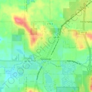
Name: Spooner topographic map, elevation, terrain.
Location: Spooner, Washburn County, Wisconsin, United States (45.80909 -91.92397 45.85082 -91.85128)
Average elevation: 336 m
Minimum elevation: 313 m
Maximum elevation: 379 m
Other topographic maps
Click on a map to view its topography, its elevation and its terrain.
Devils Lake
United States > Wisconsin > Washburn County
Devils Lake, Town of Bass Lake, Washburn County, Wisconsin, United States
Average elevation: 367 m
Tomahawk Lake
United States > Wisconsin > Washburn County
Tomahawk Lake, Town of Casey, Washburn County, Wisconsin, United States
Average elevation: 318 m
Slim Lake
United States > Wisconsin > Washburn County
Slim Lake, Town of Birchwood, Washburn County, Wisconsin, United States
Average elevation: 404 m
Town of Spooner
United States > Wisconsin > Washburn County
Town of Spooner, Washburn County, Wisconsin, 54801, United States
Average elevation: 342 m
Chicog Lake
United States > Wisconsin > Washburn County
Chicog Lake, Town of Chicog, Washburn County, Wisconsin, United States
Average elevation: 314 m
Town of Chicog
United States > Wisconsin > Washburn County
Town of Chicog, Washburn County, Wisconsin, United States
Average elevation: 310 m
Minong
United States > Wisconsin > Washburn County
Minong, Washburn County, Wisconsin, United States
Average elevation: 330 m
Crystal Mountain
United States > Wisconsin > Washburn County
Crystal Mountain, Town of Spooner, Washburn County, Wisconsin, United States
Average elevation: 344 m
Shell Lake
United States > Wisconsin > Washburn County
Shell Lake, Washburn County, Wisconsin, 53871, United States
Average elevation: 376 m
Stone Lake
United States > Wisconsin > Washburn County
Stone Lake, Town of Stone Lake, Washburn County, Wisconsin, 54876, United States
Average elevation: 405 m