
De Smet topographic map
Interactive map
Click on the map to display elevation.
About this map
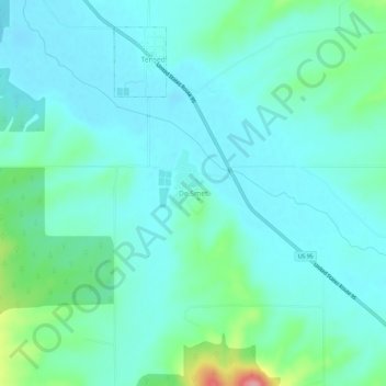
Name: De Smet topographic map, elevation, terrain.
Location: De Smet, Benewah County, Idaho, 83824, United States (47.12601 -116.93572 47.16601 -116.89572)
Average elevation: 794 m
Minimum elevation: 771 m
Maximum elevation: 894 m
U.S. Route 95 passes nearby and the community is located about a mile (1.6 km) south of Tensed, which was originally also to be titled Desmet before the name was ordered to be reversed and was subsequently misspelled by the post office. Latah Creek flows between the two communities. De Smet has a post office with a ZIP code of 83824. As of the 2010 census, its population was 145, and its elevation is approximately 2,600 feet (790 m) above sea level.
Other topographic maps
Click on a map to view its topography, its elevation and its terrain.
Benewah
United States > Idaho > Benewah County
Benewah, Benewah County, Idaho, United States
Average elevation: 925 m
Fernwood
United States > Idaho > Benewah County
Fernwood, Benewah County, Idaho, 83830, United States
Average elevation: 882 m
Saint Maries
United States > Idaho > Benewah County
Saint Maries, Benewah County, Idaho, United States
Average elevation: 689 m