
Zwillbrock topographic map
Interactive map
Click on the map to display elevation.
About this map
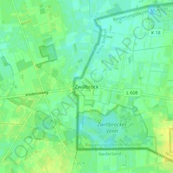
Name: Zwillbrock topographic map, elevation, terrain.
Location: Zwillbrock, Vreden, Kreis Borken, Noordrijn-Westfalen, Duitsland (52.03440 6.67153 52.07440 6.71153)
Average elevation: 31 m
Minimum elevation: 24 m
Maximum elevation: 41 m
Other topographic maps
Click on a map to view its topography, its elevation and its terrain.
Ammeloe
Duitsland > Noordrijn-Westfalen > Kreis Borken > Vreden > Ammeloe
Ammeloe, Vreden, Kreis Borken, Noordrijn-Westfalen, Duitsland
Average elevation: 36 m