
Thank you for supporting this site ❤️
Make a donation
Make a donation
County Armagh topographic map
Click on the map to display elevation.
Thank you for supporting this site ❤️
Make a donation
Make a donation
About this map
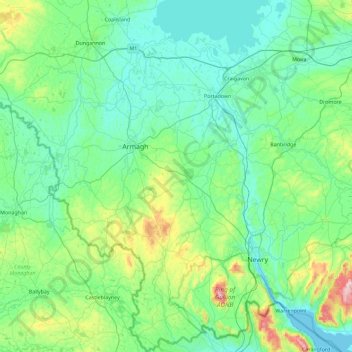
Name: County Armagh topographic map, elevation, terrain.
Location: County Armagh, Ulster, Northern Ireland, United Kingdom (54.03646 -6.87804 54.56754 -6.29086)
Average elevation: 98 m
Minimum elevation: 0 m
Maximum elevation: 569 m
Thank you for supporting this site ❤️
Make a donation
Make a donation
Other topographic maps
Click on a map to view its topography, its elevation and its terrain.
Derry/Londonderry
United Kingdom > Northern Ireland > County Londonderry
Derry is characterised by its distinctively hilly topography. The River Foyle forms a deep valley as it flows through the city, making Derry a place of very steep streets and sudden, startling views. The original walled city of Londonderry lies on a hill on the west bank of the River Foyle. In the past, the…
Average elevation: 88 m