
Make a donation
Daqing topographic map
Click on the map to display elevation.
Make a donation
About this map
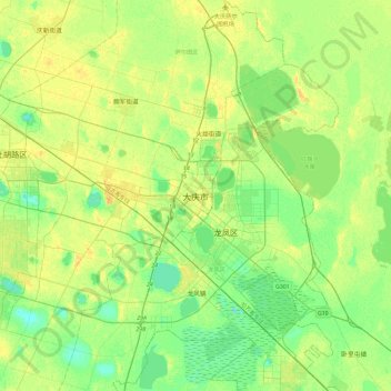
Name: Daqing topographic map, elevation, terrain.
Location: Daqing, Sartu District, Daqing City, Heilongjiang, China (46.43690 124.94148 46.75690 125.26148)
Average elevation: 148 m
Minimum elevation: 138 m
Maximum elevation: 159 m
Make a donation
Other topographic maps
Click on a map to view its topography, its elevation and its terrain.
Harbin
Harbin, with a total land area of 53,068 km2 (20,490 sq mi), is located in southern Heilongjiang province and is the provincial capital. The prefecture is also located at the southeastern edge of the Songnen Plain, a major part of China's Northeastern Plain. The city center also sits on the southern bank of…
Average elevation: 244 m
Harbin
Harbin, with a total land area of 53,068 km2 (20,490 sq mi), is located in southern Heilongjiang province and is the provincial capital. The prefecture is also located at the southeastern edge of the Songnen Plain, a major part of China's Northeastern Plain. The city center also sits on the southern bank of…
Average elevation: 250 m
Make a donation
Amur
China > Heilongjiang > Fuyuan City > Fuyuan
The river rises in the hills in the western part of Northeast China at the confluence of its two major affluents, the Shilka and the Argun (or Ergune), at an elevation of 303 metres (994 ft). It flows east forming the border between China and Russia, and slowly makes a great arc to the southeast for about 400…
Average elevation: 46 m
Harbin
Harbin, with a total land area of 53,068 km2 (20,490 sq mi), is located in southern Heilongjiang province and is the provincial capital. The prefecture is also located at the southeastern edge of the Songnen Plain, a major part of China's Northeastern Plain. The city center also sits on the southern bank of…
Average elevation: 250 m
Make a donation
Make a donation
Harbin
Harbin, with a total land area of 53,068 km2 (20,490 sq mi), is located in southern Heilongjiang province and is the provincial capital. The prefecture is also located at the southeastern edge of the Songnen Plain, a major part of China's Northeastern Plain. The city center also sits on the southern bank of…
Average elevation: 250 m
Make a donation
Mudanjiang City
It also borders Russia's Primorsky Krai to the east. The average elevation in the prefecture is 230 meters (755 ft), with the terrain primarily consisting of mountains and hills. The east of the prefecture begins to ascend to the Changbai Mountains, while the central parts belong to the Hegu Basin. The lowest…
Average elevation: 447 m
Make a donation
Make a donation
Harbin
Harbin, with a total land area of 53,068 km2 (20,490 sq mi), is located in southern Heilongjiang province and is the provincial capital. The prefecture is also located at the southeastern edge of the Songnen Plain, a major part of China's Northeastern Plain. The city center also sits on the southern bank of…
Average elevation: 250 m
Make a donation
Make a donation
Make a donation
Make a donation
Make a donation