
Aghbal topographic map
Interactive map
Click on the map to display elevation.
About this map
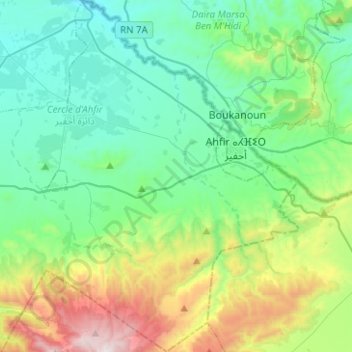
Name: Aghbal topographic map, elevation, terrain.
Average elevation: 406 m
Minimum elevation: 46 m
Maximum elevation: 1,507 m
Other topographic maps
Click on a map to view its topography, its elevation and its terrain.
Ajdir
Maroc > Cercle d'Ahfir > Fezouane
Ajdir, Fezouane, caïdat d'Aghbal, Cercle d'Ahfir, Province de Berkane, Oriental, Maroc
Average elevation: 621 m
Rehamna
Maroc > Cercle d'Ahfir > Aghbal
Rehamna, Aghbal, caïdat d'Aghbal, Cercle d'Ahfir, Province de Berkane, Oriental, 60330, Maroc
Average elevation: 342 m
Moulouya
Maroc > Cercle d'Ahfir > Madagh
Moulouya, Madagh, caïdat de Madagh, Cercle d'Ahfir, Province de Berkane, Oriental, Maroc
Average elevation: 37 m