
Dover topographic map
Interactive map
Click on the map to display elevation.
About this map
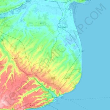
Name: Dover topographic map, elevation, terrain.
Location: Dover, Kent, Inglaterra, Reino Unido (51.09719 1.14275 51.33238 1.40621)
Average elevation: 39 m
Minimum elevation: -2 m
Maximum elevation: 189 m
Other topographic maps
Click on a map to view its topography, its elevation and its terrain.
Kettle Corner
Reino Unido > Inglaterra > Kent > Maidstone > West Farleigh
Kettle Corner, East Farleigh, West Farleigh, Maidstone, Kent, Inglaterra, ME15 0LA, Reino Unido
Average elevation: 69 m
Folkestone
Reino Unido > Inglaterra > Kent > Folkestone and Hythe
Folkestone, Folkestone and Hythe, Kent, Inglaterra, Reino Unido
Average elevation: 62 m
Gravesend
Reino Unido > Inglaterra > Kent > Gravesham
Gravesend, Gravesham, Kent, Inglaterra, Reino Unido
Average elevation: 31 m