
Ober Gabelhorn topographic map
Interactive map
Click on the map to display elevation.
About this map
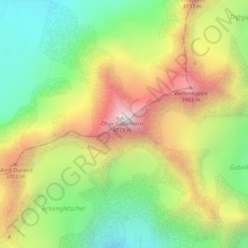
Name: Ober Gabelhorn topographic map, elevation, terrain.
Location: Ober Gabelhorn, Zermatt, Visp, Vallese, 3920, Svizzera (46.03799 7.66755 46.03809 7.66765)
Average elevation: 3,320 m
Minimum elevation: 2,744 m
Maximum elevation: 4,056 m
Other topographic maps
Click on a map to view its topography, its elevation and its terrain.
Punta Dufour (Monte Rosa)
Punta Dufour (Monte Rosa), Zermatt, Visp, Vallese, 3920, Svizzera
Average elevation: 4,033 m
Cima di Jazzi
Cima di Jazzi, Zermatt, Visp, Vallese, 3920, Svizzera
Average elevation: 3,201 m
Gabelhorngletscher
Gabelhorngletscher, Arbenbiwak, Chalbermatten, Zermatt, Visp, Vallese, 3920, Svizzera
Average elevation: 3,134 m
Breithorn Orientale
Breithorn Orientale, Zermatt, Visp, Vallese, 3920, Svizzera
Average elevation: 3,569 m
Unterrothorn
Unterrothorn, Zermatt, Visp, Vallese, 3920, Svizzera
Average elevation: 2,715 m
Gornergrat
Gornergrat, Hohtälli, Ze Seewjinen, Zermatt, Visp, Vallese, 3920, Svizzera
Average elevation: 2,768 m
Piccolo Cervino
Piccolo Cervino, Zermatt, Visp, Vallese, 3920, Svizzera
Average elevation: 3,515 m
Riffelhorn
Riffelhorn, Zermatt, Visp, Vallese, 3920, Svizzera
Average elevation: 2,572 m
Roccia Nera
Roccia Nera, Zermatt, Visp, Vallese, 3920, Svizzera
Average elevation: 3,605 m
Gobba di Rollin
Gobba di Rollin, Zermatt, Visp, Vallese, 3920, Svizzera
Average elevation: 3,590 m
Wellenkuppe
Wellenkuppe, Zermatt, Visp, Vallese, 3920, Svizzera
Average elevation: 3,326 m
Tête de valpelline
Tête de valpelline, Zermatt, Visp, Vallese, 3920, Svizzera
Average elevation: 3,368 m