
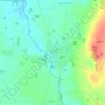
Srokowo topographic map
Interactive map
Click on the map to display elevation.
About this map
Name: Srokowo topographic map, elevation, terrain.
Average elevation: 98 m
Minimum elevation: 70 m
Maximum elevation: 163 m
Other topographic maps
Click on a map to view its topography, its elevation and its terrain.
Mażany
Poland > Warmian-Masurian Voivodeship > Kętrzyn County
Mażany, gmina Kętrzyn, Kętrzyn County, Warmian-Masurian Voivodeship, 11-400, Poland
Average elevation: 127 m
Mój
Poland > Warmian-Masurian Voivodeship > Kętrzyn County > Czerniki
Mój, Czerniki, gmina Kętrzyn, Kętrzyn County, Warmian-Masurian Voivodeship, 11-400, Poland
Average elevation: 126 m
Siercze
Poland > Warmian-Masurian Voivodeship > Kętrzyn County > Czerniki > Czerniki-Kolonia
Siercze, Czerniki-Kolonia, Czerniki, gmina Kętrzyn, Kętrzyn County, Warmian-Masurian Voivodeship, 11-400, Poland
Average elevation: 127 m