
Thank you for supporting this site ❤️
Make a donation
Make a donation
Timber Ridge topographic map
Click on the map to display elevation.
Thank you for supporting this site ❤️
Make a donation
Make a donation
About this map
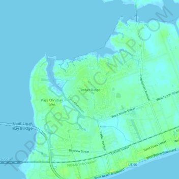
Name: Timber Ridge topographic map, elevation, terrain.
Average elevation: 3 m
Minimum elevation: -3 m
Maximum elevation: 11 m
Thank you for supporting this site ❤️
Make a donation
Make a donation
Other topographic maps
Click on a map to view its topography, its elevation and its terrain.
Bay of Saint Louis
United States > Mississippi > Harrison County > Pass Christian
Average elevation: 4 m