
Thank you for supporting this site ❤️
Make a donation
Make a donation
Barbaliche topographic map
Click on the map to display elevation.
Thank you for supporting this site ❤️
Make a donation
Make a donation
About this map
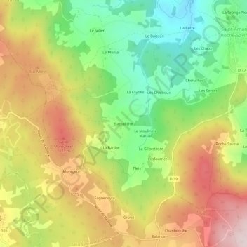
Name: Barbaliche topographic map, elevation, terrain.
Average elevation: 984 m
Minimum elevation: 781 m
Maximum elevation: 1,210 m
Thank you for supporting this site ❤️
Make a donation
Make a donation
Other topographic maps
Click on a map to view its topography, its elevation and its terrain.
63890
France > Auvergne-Rhône-Alpes > Puy-de-Dôme > Saint-Amant-Roche-Savine > Le Monial
Average elevation: 922 m