
Make a donation
Grays Peak topographic map
Click on the map to display elevation.
Make a donation
Grays Peak
Grays Peak is one of 53 fourteeners (mountains of over 14,000 feet (4,300 m) in elevation) in Colorado. Botanist Charles C. Parry made the first recorded ascent of the summit in 1861 and named the peak in honor of his botanist colleague Asa Gray. Gray did not see (and climb) the peak until 1872, eleven years later. Grays Peak is commonly mentioned in conjunction with adjacent Torreys Peak. In the Arapaho language Gray's Peak and the adjacent Torrey's Peak are named, Heeniiyoowuu or "Ant Hills".
Make a donation
About this map
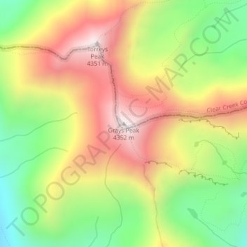
Name: Grays Peak topographic map, elevation, terrain.
Average elevation: 3,914 m
Minimum elevation: 3,497 m
Maximum elevation: 4,341 m
Make a donation
Other topographic maps
Click on a map to view its topography, its elevation and its terrain.
Make a donation
Georgetown
United States > Colorado > Clear Creek County
The town sits at an elevation of 8,530 feet (2,600 m) above sea level, nestled in the mountains near the upper end of the valley of Clear Creek in the mountains west of Denver along Interstate 70. Although population was only about 1,000 at the 2010 census, the town was a historic center of the mining industry…
Average elevation: 2,974 m