
Thank you for supporting this site ❤️
Make a donation
Make a donation
Rabenden topographic map
Click on the map to display elevation.
Thank you for supporting this site ❤️
Make a donation
Make a donation
About this map
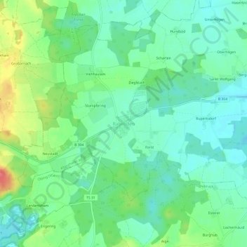
Name: Rabenden topographic map, elevation, terrain.
Average elevation: 548 m
Minimum elevation: 526 m
Maximum elevation: 598 m
Thank you for supporting this site ❤️
Make a donation
Make a donation
Other topographic maps
Click on a map to view its topography, its elevation and its terrain.
83352
Deutschland > Bayern > Landkreis Traunstein > Altenmarkt an der Alz > Berg > Thalham
Average elevation: 535 m