
Thank you for supporting this site ❤️
Make a donation
Make a donation
South Shore Park topographic map
Click on the map to display elevation.
Thank you for supporting this site ❤️
Make a donation
Make a donation
About this map
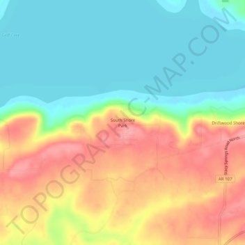
Name: South Shore Park topographic map, elevation, terrain.
Location: South Shore Park, Cleburne County, Arkansas, United States (35.44536 -92.13598 35.48536 -92.09598)
Average elevation: 182 m
Minimum elevation: 137 m
Maximum elevation: 242 m
Thank you for supporting this site ❤️
Make a donation
Make a donation
Other topographic maps
Click on a map to view its topography, its elevation and its terrain.