
Thank you for supporting this site ❤️
Make a donation
Make a donation
Olango Island topographic map
Click on the map to display elevation.
Thank you for supporting this site ❤️
Make a donation
Make a donation
About this map
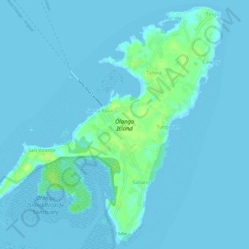
Name: Olango Island topographic map, elevation, terrain.
Location: Olango Island, Lapu-Lapu, Cebu, Central Visayas, Philippines (10.23741 124.01964 10.28879 124.07437)
Average elevation: 2 m
Minimum elevation: -3 m
Maximum elevation: 13 m
Thank you for supporting this site ❤️
Make a donation
Make a donation
Other topographic maps
Click on a map to view its topography, its elevation and its terrain.