
Kadirli topographic map
Interactive map
Click on the map to display elevation.
About this map
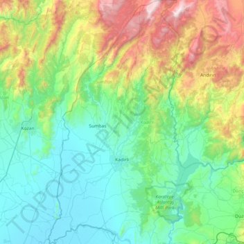
Name: Kadirli topographic map, elevation, terrain.
Location: Kadirli, Osmaniye, Mittelmeerregion, Türkei (37.17431 35.87645 37.74978 36.28511)
Average elevation: 607 m
Minimum elevation: 26 m
Maximum elevation: 2,274 m
Other topographic maps
Click on a map to view its topography, its elevation and its terrain.
Hacılar
Türkei > Mittelmeerregion > Hacılar
Hacılar, Burdur (merkez), Burdur, Mittelmeerregion, Türkei
Average elevation: 962 m
Karatepe
Türkei > Mittelmeerregion > Karatepe
Karatepe, loop road along wall of Karatepe, Karatepe, Kadirli, Osmaniye, Mittelmeerregion, Türkei
Average elevation: 163 m
Seyhan
Seyhan, Sarıçam, Adana, Mittelmeerregion, 01120, Türkei
Average elevation: 383 m
Osmaniye
Türkei > Mittelmeerregion > Osmaniye
Osmaniye, Osmaniye (merkez), Osmaniye, Mittelmeerregion, 80010, Türkei
Average elevation: 453 m
Elmalı
Türkei > Mittelmeerregion > Elmalı
Elmalı, Antalya, Mittelmeerregion, 07700, Türkei
Average elevation: 1,253 m
Kaş
Türkei > Mittelmeerregion > Kaş
Kaş, Antalya, Mittelmeerregion, 08750, Türkei
Average elevation: 298 m