
Thank you for supporting this site ❤️
Make a donation
Make a donation
Svanvik topographic map
Click on the map to display elevation.
Thank you for supporting this site ❤️
Make a donation
Make a donation
About this map
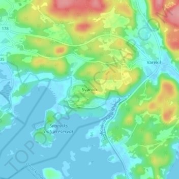
Name: Svanvik topographic map, elevation, terrain.
Location: Svanvik, Orust kommun, Västra Götaland County, 472 97, Sweden (58.09925 11.67262 58.13925 11.71262)
Average elevation: 27 m
Minimum elevation: -3 m
Maximum elevation: 101 m
Thank you for supporting this site ❤️
Make a donation
Make a donation
Other topographic maps
Click on a map to view its topography, its elevation and its terrain.
Thank you for supporting this site ❤️
Make a donation
Make a donation
Thank you for supporting this site ❤️
Make a donation
Make a donation