
Thank you for supporting this site ❤️
Make a donation
Make a donation
Imaaliouene topographic map
Click on the map to display elevation.
Thank you for supporting this site ❤️
Make a donation
Make a donation
About this map
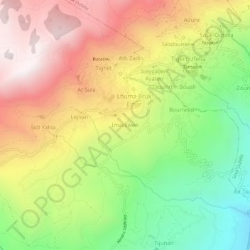
Name: Imaaliouene topographic map, elevation, terrain.
Location: Imaaliouene, Chemini, Chemini District, Bejaia, 06770, Algeria (36.57103 4.60006 36.61103 4.64006)
Average elevation: 701 m
Minimum elevation: 132 m
Maximum elevation: 1,286 m
Thank you for supporting this site ❤️
Make a donation
Make a donation
Other topographic maps
Click on a map to view its topography, its elevation and its terrain.