
Brest topographic map
Interactive map
Click on the map to display elevation.
About this map
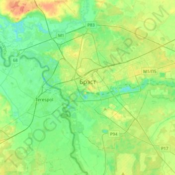
Name: Brest topographic map, elevation, terrain.
Location: Brest, Brest Region, Belarus (52.02378 23.56544 52.15245 23.85441)
Average elevation: 137 m
Minimum elevation: 123 m
Maximum elevation: 162 m
Other topographic maps
Click on a map to view its topography, its elevation and its terrain.
Беловежская пуща
Belarus > Brest Region > Каменюкский сельский Совет
Беловежская пуща, Стрела (несуществуюющая), Каменюкский сельский Совет, Kamenets District, Brest Region, Belarus
Average elevation: 163 m