
Golgotha topographic map
Interactive map
Click on the map to display elevation.
About this map
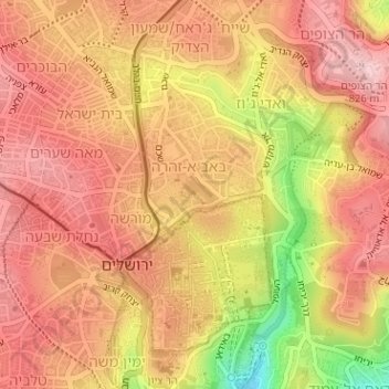
Name: Golgotha topographic map, elevation, terrain.
Average elevation: 765 m
Minimum elevation: 633 m
Maximum elevation: 828 m
Other topographic maps
Click on a map to view its topography, its elevation and its terrain.
Jérusalem
Israël > District de Jérusalem > Jérusalem
Jérusalem, District de Jérusalem, Israël
Average elevation: 661 m