
Thank you for supporting this site ❤️
Make a donation
Make a donation
Agnarone topographic map
Click on the map to display elevation.
Thank you for supporting this site ❤️
Make a donation
Make a donation
About this map
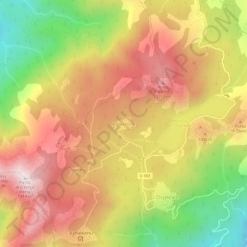
Name: Agnarone topographic map, elevation, terrain.
Average elevation: 938 m
Minimum elevation: 494 m
Maximum elevation: 1,298 m
Thank you for supporting this site ❤️
Make a donation
Make a donation
Other topographic maps
Click on a map to view its topography, its elevation and its terrain.
Porto-Vecchio (canton de Bavella)
France > Corse > Corse-du-Sud > Porto-Vecchio
Average elevation: 71 m