
Thank you for supporting this site ❤️
Make a donation
Make a donation
Jefferson Heights topographic map
Click on the map to display elevation.
Thank you for supporting this site ❤️
Make a donation
Make a donation
About this map
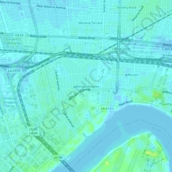
Name: Jefferson Heights topographic map, elevation, terrain.
Average elevation: 3 m
Minimum elevation: -1 m
Maximum elevation: 13 m
Thank you for supporting this site ❤️
Make a donation
Make a donation
Other topographic maps
Click on a map to view its topography, its elevation and its terrain.
Kenner
United States > Louisiana > Jefferson Parish
Kenner's coordinates are 30°0′35″N 90°15′2″W / 30.00972°N 90.25056°W / 30.00972; -90.25056 (30.009610, −90.250585) and has an elevation of 0 ft (0 m).
Average elevation: 1 m
Thank you for supporting this site ❤️
Make a donation
Make a donation
Thank you for supporting this site ❤️
Make a donation
Make a donation
Gretna
United States > Louisiana > Jefferson Parish
Gretna is located at 29°54′59″N 90°3′15″W / 29.91639°N 90.05417°W / 29.91639; -90.05417 (29.916459, -90.054260) and has an elevation of 0 feet (0 m) behind the levee along the Mississippi River.
Average elevation: 2 m
Thank you for supporting this site ❤️
Make a donation
Make a donation