Geolocate

Wichita topographic map

Interactive map

Click on the map to display elevation.

About this map

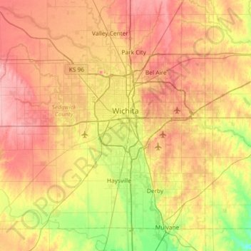
Name: Wichita topographic map, elevation, terrain.

Location: Wichita, Sedgwick County, Kansas, United States (37.48902 -97.73435 37.84020 -97.15300)

Average elevation: 408 m

Minimum elevation: 355 m

Maximum elevation: 459 m

The city lies on the Arkansas River near the western edge of the Flint Hills in the Wellington-McPherson Lowlands region of the Great Plains. The area's topography is characterized by the broad alluvial plain of the Arkansas River valley and the moderately rolling slopes that rise to the higher lands on either side.

Wikipedia (CC-BY-SA 3.0)

Other topographic maps

Click on a map to view its topography, its elevation and its terrain.

Colwich

United States > Kansas > Sedgwick County

Colwich, Sedgwick County, Kansas, United States

Average elevation: 421 m

Mulvane

United States > Kansas > Sedgwick County

Mulvane, Sedgwick County, Kansas, 67110, United States

Average elevation: 386 m

Wichita

United States > Kansas > Sedgwick County > Wichita

Wichita, Sedgwick County, Kansas, 67202, United States

Average elevation: 410 m

Andale

United States > Kansas > Sedgwick County

Andale, Sedgwick County, Kansas, United States

Average elevation: 440 m

Kechi

United States > Kansas > Sedgwick County

Kechi, Sedgwick County, Kansas, United States

Average elevation: 429 m

Garden Plain

United States > Kansas > Sedgwick County

Garden Plain, Sedgwick County, Kansas, United States

Average elevation: 444 m

Bel Aire

United States > Kansas > Sedgwick County

Bel Aire, Sedgwick County, Kansas, United States

Average elevation: 424 m

Maize

United States > Kansas > Sedgwick County

Maize, Sedgwick County, Kansas, United States

Average elevation: 414 m

Valley Center

United States > Kansas > Sedgwick County

Valley Center, Sedgwick County, Kansas, United States

Average elevation: 413 m

Park City

United States > Kansas > Sedgwick County

Park City, Sedgwick County, Kansas, United States

Average elevation: 421 m

Haysville

United States > Kansas > Sedgwick County

Haysville, Riverside Township, Sedgwick County, Kansas, United States

Average elevation: 388 m

Minneha

United States > Kansas > Sedgwick County > Wichita

Minneha, Wichita, Sedgwick County, Kansas, 67206, United States

Average elevation: 423 m

Valley Center

United States > Kansas > Sedgwick County > Valley Center > Valley Center

Valley Center, Sedgwick County, Kansas, United States

Average elevation: 415 m

Derby

United States > Kansas > Sedgwick County

Derby, Sedgwick County, Kansas, 67037, United States

Average elevation: 393 m

Mount Hope

United States > Kansas > Sedgwick County > Mount Hope

Mount Hope, Sedgwick County, Kansas, United States

Average elevation: 439 m