
Thank you for supporting this site ❤️
Make a donation
Make a donation
El Coto topographic map
Click on the map to display elevation.
Thank you for supporting this site ❤️
Make a donation
Make a donation
About this map
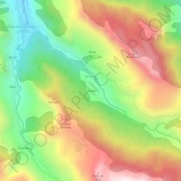
Name: El Coto topographic map, elevation, terrain.
Location: El Coto, Somiedo, Asturias, 33840, España (43.05950 -6.25667 43.09950 -6.21667)
Average elevation: 1,179 m
Minimum elevation: 666 m
Maximum elevation: 1,752 m
Thank you for supporting this site ❤️
Make a donation
Make a donation
Other topographic maps
Click on a map to view its topography, its elevation and its terrain.