
Adderbury topographic map
Interactive map
Click on the map to display elevation.
About this map
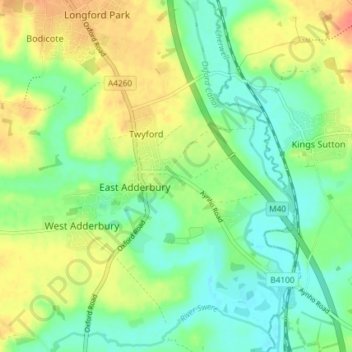
Name: Adderbury topographic map, elevation, terrain.
Average elevation: 100 m
Minimum elevation: 79 m
Maximum elevation: 132 m
Other topographic maps
Click on a map to view its topography, its elevation and its terrain.
Ambrosden
United Kingdom > England > Oxfordshire > Cherwell District
Ambrosden, Cherwell District, Oxfordshire, England, United Kingdom
Average elevation: 66 m
Cottisford
United Kingdom > England > Oxfordshire > Cherwell District
Cottisford, Cherwell District, Oxfordshire, England, United Kingdom
Average elevation: 121 m
Launton
United Kingdom > England > Oxfordshire > Cherwell District
Launton, Cherwell District, Oxfordshire, England, United Kingdom
Average elevation: 73 m
Kirtlington
United Kingdom > England > Oxfordshire > Cherwell District
Kirtlington, Cherwell District, Oxfordshire, England, United Kingdom
Average elevation: 89 m
Deddington
United Kingdom > England > Oxfordshire > Cherwell District
Deddington, Cherwell District, Oxfordshire, England, United Kingdom
Average elevation: 107 m
Bicester
United Kingdom > England > Oxfordshire > Cherwell District
Bicester, Cherwell District, Oxfordshire, England, United Kingdom
Average elevation: 76 m
Banbury
United Kingdom > England > Oxfordshire > Cherwell District
Banbury, Cherwell District, Oxfordshire, England, United Kingdom
Average elevation: 116 m