
Thank you for supporting this site ❤️
Make a donation
Make a donation
Miami County topographic map
Click on the map to display elevation.
Thank you for supporting this site ❤️
Make a donation
Make a donation
About this map
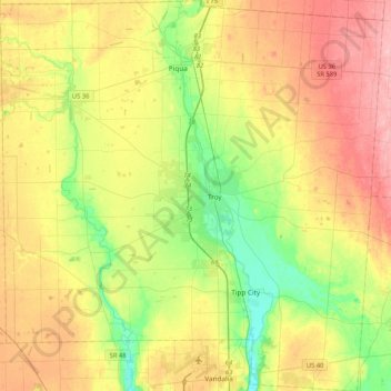
Name: Miami County topographic map, elevation, terrain.
Location: Miami County, Ohio, United States (39.88010 -84.43656 40.19988 -84.02325)
Average elevation: 292 m
Minimum elevation: 234 m
Maximum elevation: 363 m
Thank you for supporting this site ❤️
Make a donation
Make a donation
Other topographic maps
Click on a map to view its topography, its elevation and its terrain.