
Jarosław County topographic map
Interactive map
Click on the map to display elevation.
About this map
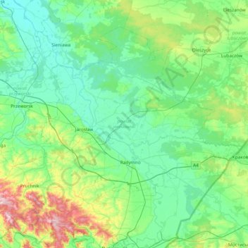
Name: Jarosław County topographic map, elevation, terrain.
Location: Jarosław County, Subcarpathian Voivodeship, Poland (49.83732 22.41048 50.21290 23.15428)
Average elevation: 216 m
Minimum elevation: 166 m
Maximum elevation: 430 m
Other topographic maps
Click on a map to view its topography, its elevation and its terrain.
Dział
Poland > Subcarpathian Voivodeship > Rzeszów County > Piątkowa
Dział, Piątkowa, gmina Błażowa, Rzeszów County, Subcarpathian Voivodeship, 36-035, Poland
Average elevation: 337 m
Żołynia
Poland > Subcarpathian Voivodeship > Łańcut County
Żołynia, gmina Żołynia, Łańcut County, Subcarpathian Voivodeship, 37-110, Poland
Average elevation: 222 m
Kantorek
Poland > Subcarpathian Voivodeship > Sanok County > Czaszyn
Kantorek, Czaszyn, gmina Zagórz, Sanok County, Subcarpathian Voivodeship, 38-516, Poland
Average elevation: 441 m
Krosno
Poland > Subcarpathian Voivodeship
Krosno, Subcarpathian Voivodeship, Poland
Average elevation: 282 m
Dębica
Poland > Subcarpathian Voivodeship > Dębica County
Dębica, Dębica County, Subcarpathian Voivodeship, 39-200, Poland
Average elevation: 233 m
Jastkowice
Poland > Subcarpathian Voivodeship > Stalowa Wola County
Jastkowice, gmina Pysznica, Stalowa Wola County, Subcarpathian Voivodeship, Poland
Average elevation: 159 m
Głogów Małopolski
Poland > Subcarpathian Voivodeship > Rzeszów County
Głogów Małopolski, gmina Głogów Małopolski, Rzeszów County, Subcarpathian Voivodeship, 36-060, Poland
Average elevation: 225 m
Strzyżów
Poland > Subcarpathian Voivodeship > Strzyżów County
Strzyżów, gmina Strzyżów, Strzyżów County, Subcarpathian Voivodeship, 38-100, Poland
Average elevation: 268 m
Rzeszów
Poland > Subcarpathian Voivodeship
Rzeszów, Subcarpathian Voivodeship, Poland
Average elevation: 238 m
Podkościele
Poland > Subcarpathian Voivodeship > Dębica County > Łęki Górne
Podkościele, Łęki Górne, gmina Pilzno, Dębica County, Subcarpathian Voivodeship, 39-221, Poland
Average elevation: 254 m
Ropczyce
Poland > Subcarpathian Voivodeship > Ropczyce-Sędziszów County
Ropczyce, gmina Ropczyce, Ropczyce-Sędziszów County, Subcarpathian Voivodeship, 39-100, Poland
Average elevation: 250 m
Krzeszów
Poland > Subcarpathian Voivodeship > Nisko County
Krzeszów, gmina Krzeszów, Nisko County, Subcarpathian Voivodeship, Poland
Average elevation: 180 m
Dębica
Poland > Subcarpathian Voivodeship > Dębica County > Dębica
Dębica, Dębica County, Subcarpathian Voivodeship, 39-200, Poland
Average elevation: 234 m
Rzeszów
Poland > Subcarpathian Voivodeship > Rzeszów
Rzeszów, Subcarpathian Voivodeship, Poland
Average elevation: 239 m
Rzeki
Poland > Subcarpathian Voivodeship > Jasło County > Błażkowa > Rzeki
Rzeki, Błażkowa, gmina Brzyska, Jasło County, Subcarpathian Voivodeship, 38-212, Poland
Average elevation: 260 m
Przemyśl
Poland > Subcarpathian Voivodeship > Przemyśl > Przemyśl
Przemyśl, Subcarpathian Voivodeship, 37-700, Poland
Average elevation: 267 m
Sanok
Poland > Subcarpathian Voivodeship > Sanok County > Sanok
Sanok, Sanok County, Subcarpathian Voivodeship, Poland
Average elevation: 354 m
Bulwar WSK Rzeszów
Poland > Subcarpathian Voivodeship > Rzeszów
Bulwar WSK Rzeszów, Dąbrowskiego, Rzeszów, Subcarpathian Voivodeship, Poland
Average elevation: 208 m
Sanok County
Poland > Subcarpathian Voivodeship
Sanok County, Subcarpathian Voivodeship, Poland
Average elevation: 479 m
Stalowa Wola
Poland > Subcarpathian Voivodeship > Stalowa Wola
Stalowa Wola, Stalowa Wola County, Subcarpathian Voivodeship, Poland
Average elevation: 159 m
Olimpów
Poland > Subcarpathian Voivodeship > Olimpów
Olimpów, gmina Iwierzyce, Ropczyce-Sędziszów County, Subcarpathian Voivodeship, Poland
Average elevation: 276 m
Łączki Kucharskie
Poland > Subcarpathian Voivodeship > Łączki Kucharskie
Łączki Kucharskie, gmina Ropczyce, Ropczyce-Sędziszów County, Subcarpathian Voivodeship, Poland
Average elevation: 284 m
Ryli
Poland > Subcarpathian Voivodeship > Zatwarnica
Ryli, Zatwarnica, gmina Lutowiska, Bieszczady County, Subcarpathian Voivodeship, Poland
Average elevation: 597 m
Łańcut
Poland > Subcarpathian Voivodeship > Łańcut
Łańcut, Łańcut County, Subcarpathian Voivodeship, 37-100, Poland
Average elevation: 214 m
Zarzecze
Poland > Subcarpathian Voivodeship > Dąbrówki > Zarzecze
Zarzecze, Dąbrówki, gmina Czarna, powiat łańcucki, Subcarpathian Voivodeship, 37-100, Poland
Average elevation: 191 m
powiat jasielski
Poland > Subcarpathian Voivodeship
powiat jasielski, Subcarpathian Voivodeship, Poland
Average elevation: 397 m
Bieszczady County
Poland > Subcarpathian Voivodeship
Bieszczady County, Subcarpathian Voivodeship, Poland
Average elevation: 554 m
Markowa
Poland > Subcarpathian Voivodeship > Łańcut County
Markowa, gmina Markowa, Łańcut County, Subcarpathian Voivodeship, 37-120, Poland
Average elevation: 241 m
Krościenko
Poland > Subcarpathian Voivodeship > Krościenko
Krościenko, gmina Ustrzyki Dolne, powiat bieszczadzki, Subcarpathian Voivodeship, Poland
Average elevation: 514 m
Krosno
Poland > Subcarpathian Voivodeship > Krosno
Krosno, Subcarpathian Voivodeship, Poland
Average elevation: 281 m
Jarosław
Poland > Subcarpathian Voivodeship > Jarosław
Jarosław, powiat jarosławski, Subcarpathian Voivodeship, 37-500, Poland
Average elevation: 193 m
Town Centre
Poland > Subcarpathian Voivodeship > Rzeszów
Town Centre, Rzeszów, Subcarpathian Voivodeship, Poland
Average elevation: 207 m
Boguchwała
Poland > Subcarpathian Voivodeship > Rzeszów County
Boguchwała, gmina Boguchwała, Rzeszów County, Subcarpathian Voivodeship, 36-040, Poland
Average elevation: 218 m
Giewont
Poland > Subcarpathian Voivodeship > Żołynia
Giewont, Żołynia, gmina Żołynia, powiat łańcucki, Subcarpathian Voivodeship, 37-110, Poland
Average elevation: 216 m