
Bakum topographic map
Interactive map
Click on the map to display elevation.
About this map
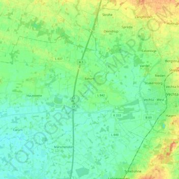
Name: Bakum topographic map, elevation, terrain.
Location: Bakum, Landkreis Vechta, Basse-Saxe, 49456, Allemagne (52.69621 8.04632 52.77206 8.25255)
Average elevation: 35 m
Minimum elevation: 24 m
Maximum elevation: 58 m
Other topographic maps
Click on a map to view its topography, its elevation and its terrain.
Neuenkirchen-Vörden
Allemagne > Basse-Saxe > Landkreis Vechta > Grapperhausen
Neuenkirchen-Vörden, Grapperhausen, Landkreis Vechta, Basse-Saxe, 49434, Allemagne
Average elevation: 49 m