
Make a donation
Mitterfels topographic map
Click on the map to display elevation.
Make a donation
About this map
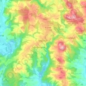
Name: Mitterfels topographic map, elevation, terrain.
Average elevation: 398 m
Minimum elevation: 325 m
Maximum elevation: 489 m
Make a donation
Other topographic maps
Click on a map to view its topography, its elevation and its terrain.
Make a donation
Make a donation
Make a donation
Make a donation
Make a donation
Make a donation
Irlbach an der Donau
Deutschland > Bayern > Landkreis Straubing-Bogen > Irlbach
Average elevation: 321 m
Make a donation
Make a donation
Untermühlbach
Deutschland > Bayern > Landkreis Straubing-Bogen > Obermühlbach
Average elevation: 477 m
Make a donation
St. Leonhardsquelle
Deutschland > Bayern > Landkreis Straubing-Bogen > Mitterberg
Average elevation: 808 m
Make a donation
Make a donation
Hinterdegenberg
Deutschland > Bayern > Landkreis Straubing-Bogen > Allersdorf
Average elevation: 578 m
Make a donation
Make a donation
Westen
Deutschland > Bayern > Landkreis Straubing-Bogen > Mallersdorf-Pfaffenberg
Average elevation: 410 m
Bogenberg
Deutschland > Bayern > Landkreis Straubing-Bogen > Bogen > Bogenberg
Average elevation: 326 m
Make a donation
Talmühle
Deutschland > Bayern > Landkreis Straubing-Bogen > Scheibelsgrub > Talmühle
Average elevation: 408 m
Sallach
Deutschland > Bayern > Landkreis Straubing-Bogen > Geiselhöring > Sallach
Average elevation: 372 m
Make a donation
Niederlindhart
Deutschland > Bayern > Landkreis Straubing-Bogen > Mallersdorf-Pfaffenberg > Niederlindhart
Average elevation: 407 m
Make a donation
Make a donation
Make a donation