
Thank you for supporting this site ❤️
Make a donation
Make a donation
Rukuhia topographic map
Click on the map to display elevation.
Thank you for supporting this site ❤️
Make a donation
Make a donation
About this map
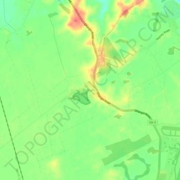
Name: Rukuhia topographic map, elevation, terrain.
Location: Rukuhia, Waipa District, Waikato, 3282, New Zealand (-37.87354 175.28491 -37.83354 175.32491)
Average elevation: 56 m
Minimum elevation: 30 m
Maximum elevation: 87 m
Thank you for supporting this site ❤️
Make a donation
Make a donation
Other topographic maps
Click on a map to view its topography, its elevation and its terrain.
Rangiaowhia War Memorial Domain
New Zealand > Waikato > Waipa District > Kihikihi > Rangiaowhia
Average elevation: 69 m