
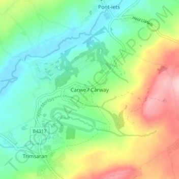
Carwe / Carway topographic map
Interactive map
Click on the map to display elevation.
About this map
Name: Carwe / Carway topographic map, elevation, terrain.
Average elevation: 75 m
Minimum elevation: 4 m
Maximum elevation: 211 m
Other topographic maps
Click on a map to view its topography, its elevation and its terrain.
Kidwelly
Royaume-Uni > Pays de Galles > Carmarthenshire
Kidwelly, Carmarthenshire, Pays de Galles, SA17 4SU, Royaume-Uni
Average elevation: 52 m
Carmarthen
Royaume-Uni > Pays de Galles > Carmarthenshire
Carmarthen, Carmarthenshire, Pays de Galles, SA31 1RT, Royaume-Uni
Average elevation: 74 m
Pentre cwrt
Royaume-Uni > Pays de Galles > Carmarthenshire
Pentre cwrt, Llangeler, Carmarthenshire, Pays de Galles, SA44 5DG, Royaume-Uni
Average elevation: 122 m
Cross Hands
Royaume-Uni > Pays de Galles > Carmarthenshire
Cross Hands, Carmarthenshire, Pays de Galles, SA14 6NA, Royaume-Uni
Average elevation: 163 m
Llangadog
Royaume-Uni > Pays de Galles > Carmarthenshire
Llangadog, Carmarthenshire, Pays de Galles, SA19 9AH, Royaume-Uni
Average elevation: 65 m
Rhosmaen
Royaume-Uni > Pays de Galles > Carmarthenshire > Llandeilo
Rhosmaen, Manordeilo and Salem, Llandeilo, Carmarthenshire, Pays de Galles, SA19 6NP, Royaume-Uni
Average elevation: 65 m