
Thank you for supporting this site ❤️
Make a donation
Make a donation
Montfaucon topographic map
Click on the map to display elevation.
Thank you for supporting this site ❤️
Make a donation
Make a donation
About this map
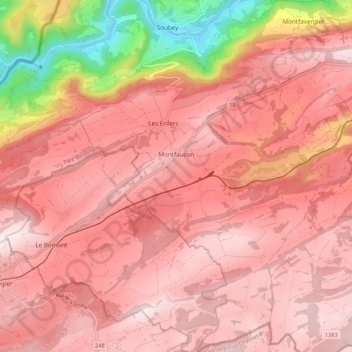
Name: Montfaucon topographic map, elevation, terrain.
Location: Montfaucon, District des Franches-Montagnes, Jura, 2362, Suisse (47.24174 7.03034 47.31379 7.10890)
Average elevation: 904 m
Minimum elevation: 472 m
Maximum elevation: 1,075 m
Thank you for supporting this site ❤️
Make a donation
Make a donation
Other topographic maps
Click on a map to view its topography, its elevation and its terrain.