
Thank you for supporting this site ❤️
Make a donation
Make a donation
Gandok topographic map
Click on the map to display elevation.
Thank you for supporting this site ❤️
Make a donation
Make a donation
About this map
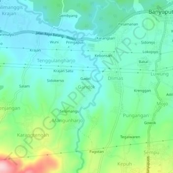
Name: Gandok topographic map, elevation, terrain.
Location: Gandok, Batang, Central Java, Java, 51271, Indonesia (-7.01039 109.89049 -6.97039 109.93049)
Average elevation: 217 m
Minimum elevation: 155 m
Maximum elevation: 399 m
Thank you for supporting this site ❤️
Make a donation
Make a donation
Other topographic maps
Click on a map to view its topography, its elevation and its terrain.