
Make a donation
El Portal topographic map
Click on the map to display elevation.
Make a donation
About this map
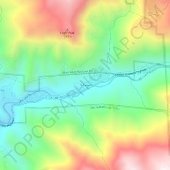
Name: El Portal topographic map, elevation, terrain.
Average elevation: 937 m
Minimum elevation: 525 m
Maximum elevation: 1,556 m
Make a donation
Other topographic maps
Click on a map to view its topography, its elevation and its terrain.
Mariposa
United States > California > Mariposa County > Mariposa
Mariposa is located at 37°29′06″N 119°57′59″W / 37.48500°N 119.96639°W / 37.48500; -119.96639, at 1,949 feet (594 m) in elevation. It lies in the rugged foothills of the Sierra Nevada. Mariposa Creek flows through the town. Soils in the urban area are mostly brown to reddish brown loam of…
Average elevation: 686 m
Tenaya Lake
United States > California > Mariposa County
Tenaya Lake is an alpine lake in Yosemite National Park, located between Yosemite Valley and Tuolumne Meadows. The surface of Tenaya Lake has an elevation of 8,150 feet (2,484 m). The lake basin was formed by glacial action, which left a backdrop of light granite rocks, whose beauty was known to the Native…
Average elevation: 2,605 m