
Make a donation
Werlsiepen topographic map
Click on the map to display elevation.
Make a donation
About this map
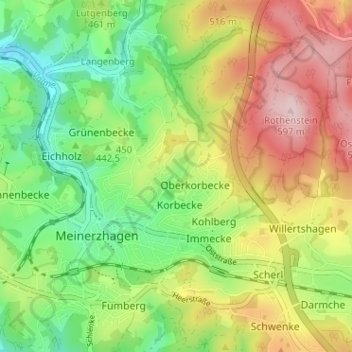
Name: Werlsiepen topographic map, elevation, terrain.
Average elevation: 458 m
Minimum elevation: 349 m
Maximum elevation: 600 m
Make a donation
Other topographic maps
Click on a map to view its topography, its elevation and its terrain.
Hunswinkel
Deutschland > Nordrhein-Westfalen > Märkischer Kreis > Meinerzhagen
Average elevation: 378 m
Werkshagen
Deutschland > Nordrhein-Westfalen > Märkischer Kreis > Meinerzhagen
Average elevation: 482 m
58540
Deutschland > Nordrhein-Westfalen > Märkischer Kreis > Meinerzhagen > Blomberg
Average elevation: 433 m
Make a donation
Sundhellen
Deutschland > Nordrhein-Westfalen > Märkischer Kreis > Meinerzhagen
Average elevation: 401 m
Lister
Deutschland > Nordrhein-Westfalen > Märkischer Kreis > Meinerzhagen
Die Lister verläuft innerhalb des Sauerlands im Naturpark Sauerland-Rothaargebirge. Sie entspringt innerhalb des Ebbegebirges, nördlich des Bergs Rothenstein (ca. 600 m ü. NHN). Ihre im Hochmoor Grundlose gelegene Quelle liegt im Naturschutzgebiet Auf’m Ebbe/Ebbemoore, das sich zwischen den zum…
Average elevation: 436 m