
Troisdorf topographic map
Interactive map
Click on the map to display elevation.
About this map
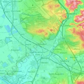
Name: Troisdorf topographic map, elevation, terrain.
Average elevation: 72 m
Minimum elevation: 41 m
Maximum elevation: 170 m
Other topographic maps
Click on a map to view its topography, its elevation and its terrain.
Sankt Augustin
Allemagne > Rhénanie-du-Nord-Westphalie > Rhein-Sieg-Kreis
Sankt Augustin, Rhein-Sieg-Kreis, Rhénanie-du-Nord-Westphalie, 53757, Allemagne
Average elevation: 79 m
Rheinbach
Allemagne > Rhénanie-du-Nord-Westphalie > Rhein-Sieg-Kreis
Rheinbach, Rhein-Sieg-Kreis, Rhénanie-du-Nord-Westphalie, 53359, Allemagne
Average elevation: 232 m
Bornheim
Allemagne > Rhénanie-du-Nord-Westphalie > Rhein-Sieg-Kreis
Bornheim, Rhein-Sieg-Kreis, Rhénanie-du-Nord-Westphalie, 53332, Allemagne
Average elevation: 96 m