
Make a donation
Egham Hythe topographic map
Click on the map to display elevation.
Make a donation
About this map
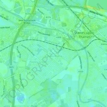
Name: Egham Hythe topographic map, elevation, terrain.
Average elevation: 16 m
Minimum elevation: 10 m
Maximum elevation: 26 m
Make a donation
Other topographic maps
Click on a map to view its topography, its elevation and its terrain.
Cooper's Hill Slopes
United Kingdom > England > Surrey > Borough of Runnymede > Englefield Green
Average elevation: 38 m
Make a donation
Addlestone
United Kingdom > England > Surrey > Borough of Runnymede
Elevations range between 11 metres (36 ft) and 40 metres (130 ft). The maximum is on Row Hill recreation ground, Row Town, Addlestone; a ridge that continues to the northwest of Row Town where it is known as Ongar/Spinney Hill, where Great Grove Farm in its centre also reaches this height; the minimum is by…
Average elevation: 18 m
Chertsey
United Kingdom > England > Surrey > Borough of Runnymede
Samuel Lewis devotes one of his longest entries to the small town in his 1848 topographical guide to England.
Average elevation: 17 m
Make a donation
Chertsey
United Kingdom > England > Surrey > Borough of Runnymede
Samuel Lewis devotes one of his longest entries to the small town in his 1848 topographical guide to England.
Average elevation: 22 m
Egham Wick
United Kingdom > England > Surrey > Borough of Runnymede > Englefield Green
Average elevation: 55 m
Make a donation
Lyn Mushroom Farm
United Kingdom > England > Surrey > Borough of Runnymede > Lyne
Average elevation: 39 m
Make a donation
Make a donation
Addlestone
United Kingdom > England > Surrey > Borough of Runnymede
Elevations range between 11 and 40 metres (36 and 131 ft). The maximum is on Row Hill recreation ground, Row Town, Addlestone; a ridge that continues to the northwest of Row Town where it is known as Ongar/Spinney Hill, where Great Grove Farm in its centre also reaches this height; the minimum is by the Thames…
Average elevation: 18 m
Chertsey
United Kingdom > England > Surrey > Borough of Runnymede
Samuel Lewis devotes one of his longest entries to the small town in his 1848 topographical guide to England.
Average elevation: 17 m
Addlestone
United Kingdom > England > Surrey > Borough of Runnymede
Elevations range between 11 metres (36 ft) and 40 metres (130 ft). The maximum is on Row Hill recreation ground, Row Town, Addlestone; a ridge that continues to the northwest of Row Town where it is known as Ongar/Spinney Hill, where Great Grove Farm in its centre also reaches this height; the minimum is by…
Average elevation: 18 m
Make a donation
Chertsey
United Kingdom > England > Surrey > Borough of Runnymede
Samuel Lewis devotes one of his longest entries to the small town in his 1848 topographical guide to England.
Average elevation: 17 m
Chertsey
United Kingdom > England > Surrey > Borough of Runnymede
Samuel Lewis devotes one of his longest entries to the small town in his 1848 topographical guide to England.
Average elevation: 22 m