
Thank you for supporting this site ❤️
Make a donation
Make a donation
Hofstetten topographic map
Click on the map to display elevation.
Thank you for supporting this site ❤️
Make a donation
Make a donation
About this map
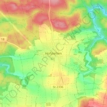
Name: Hofstetten topographic map, elevation, terrain.
Average elevation: 457 m
Minimum elevation: 406 m
Maximum elevation: 509 m
Thank you for supporting this site ❤️
Make a donation
Make a donation
Other topographic maps
Click on a map to view its topography, its elevation and its terrain.
Beilngries
Deutschland > Bayern > Landkreis Eichstätt
Auf einer Anhöhe oberhalb der Stadt Beilngries liegt das Schloss Hirschberg. Es wurde im 20. Jahrhundert zum Bistumshaus umgestaltet, unter anderem durch Erweiterungsbauten wie eine von Alexander von Branca entworfene Kapelle. Karljosef Schattner errichtete von 1987 bis 1992 den Neubau.
Average elevation: 480 m