
Make a donation
Page topographic map
Click on the map to display elevation.
Make a donation
About this map
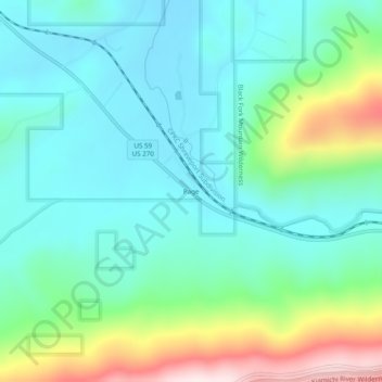
Name: Page topographic map, elevation, terrain.
Location: Page, LeFlore County, Oklahoma, United States (34.69066 -94.56967 34.73066 -94.52967)
Average elevation: 388 m
Minimum elevation: 260 m
Maximum elevation: 765 m
Make a donation
Other topographic maps
Click on a map to view its topography, its elevation and its terrain.
Poteau
United States > Oklahoma > LeFlore County
The city is located in the valley below Cavanal Hill, dubbed the "World's Highest Hill" with a signed elevation of 1,999 feet (609 m). The location was a subject of extensive coal mining in the first half of the 20th century, and a railway, eventually called the Poteau and Cavanal Mountain Railroad, served the…
Average elevation: 189 m
Make a donation
Poteau
United States > Oklahoma > LeFlore County
The city is located in the valley below Cavanal Hill, dubbed the "World's Highest Hill" with a signed elevation of 1,999 feet (609 m). The location was a subject of extensive coal mining in the first half of the 20th Century, and a railway, eventually called the Poteau and Cavanal Mountain Railroad, served the…
Average elevation: 189 m
Make a donation