
Make a donation
Streatley topographic map
Click on the map to display elevation.
Make a donation
Streatley
Streatley is a village and civil parish on the River Thames in Berkshire, England. The village faces Goring-on-Thames. The two places share in their shops, services, leisure, sports and much of their transport. Across the river is Goring & Streatley railway station and the village cluster adjoins a lock and weir. The west of the village is a mixture of agriculture and woodland plus a golf course. The village has a riverside hotel. Much of Streatley is at steeply varying elevations, ranging from 51m AOD to 185m at Streatley Warren, a hilltop point on its western border forming the eastern end of the Berkshire Downs. This Area of Outstanding Natural Beauty is topped by the 87-mile The Ridgeway path, which crosses the Thames at Goring and Streatley Bridge.
Make a donation
About this map
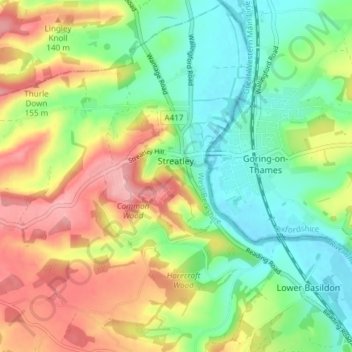
Name: Streatley topographic map, elevation, terrain.
Location: Streatley, West Berkshire, England, United Kingdom (51.49678 -1.20928 51.54291 -1.13443)
Average elevation: 95 m
Minimum elevation: 39 m
Maximum elevation: 175 m
Make a donation
Other topographic maps
Click on a map to view its topography, its elevation and its terrain.