
Thank you for supporting this site ❤️
Make a donation
Make a donation
Sekota topographic map
Click on the map to display elevation.
Thank you for supporting this site ❤️
Make a donation
Make a donation
Sekota
Sekota, also spelled Sokota, Sakota, Soqota (Amharic: ሰቆጣ; formerly ሰቈጣ) is a town and separate woreda in northern Ethiopia. The name is likely from the Agaw word sekut, "fortified village." Located in the Wag Hemra Zone of the Amhara Region, Sekota has a latitude and longitude of 12°37′31″N 39°02′06″E / 12.62528°N 39.03500°E / 12.62528; 39.03500 and an elevation of 2266 meters above sea level. It is surrounded by woreda of Soqota.
Thank you for supporting this site ❤️
Make a donation
Make a donation
About this map
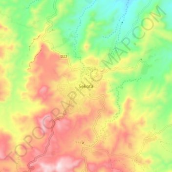
Name: Sekota topographic map, elevation, terrain.
Location: Sekota, Wag Hemra Zone, Amhara Region, Ethiopia (12.58570 38.99544 12.66570 39.07544)
Average elevation: 2,216 m
Minimum elevation: 1,867 m
Maximum elevation: 2,598 m
Thank you for supporting this site ❤️
Make a donation
Make a donation