
Heilwood topographic map
Interactive map
Click on the map to display elevation.
About this map
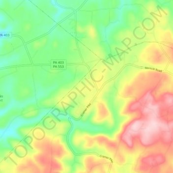
Name: Heilwood topographic map, elevation, terrain.
Average elevation: 523 m
Minimum elevation: 426 m
Maximum elevation: 648 m
Other topographic maps
Click on a map to view its topography, its elevation and its terrain.
Mentcle
United States > Pennsylvania > Indiana County > Pine Township
Mentcle, Pine Township, Indiana County, Pennsylvania, 15761, United States
Average elevation: 555 m
Alverda
United States > Pennsylvania > Indiana County > Pine Township
Alverda, Pine Township, Indiana County, Pennsylvania, 15710, United States
Average elevation: 581 m
Strongstown
United States > Pennsylvania > Indiana County > Pine Township
Strongstown, Pine Township, Indiana County, Pennsylvania, 15957, United States
Average elevation: 559 m