
Plage Joseph topographic map
Interactive map
Click on the map to display elevation.
About this map
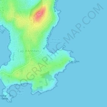
Name: Plage Joseph topographic map, elevation, terrain.
Average elevation: 10 m
Minimum elevation: -1 m
Maximum elevation: 74 m
Other topographic maps
Click on a map to view its topography, its elevation and its terrain.
Fort-Carré
France > Provence-Alpes-Côte d'Azur > Antibes
Fort-Carré, Sentier Piétonnier du Fort Carré, Val Claret, La Fontonne, Antibes, Grasse, Alpes-Maritimes, Provence-Alpes-Côte d'Azur, France métropolitaine, 06600, France
Average elevation: 10 m