
Thank you for supporting this site ❤️
Make a donation
Make a donation
Lely topographic map
Click on the map to display elevation.
Thank you for supporting this site ❤️
Make a donation
Make a donation
About this map
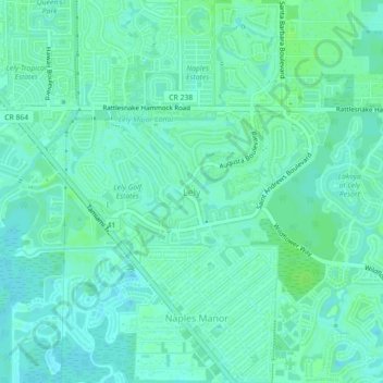
Name: Lely topographic map, elevation, terrain.
Location: Lely, Collier County, Florida, 34113, United States (26.08050 -81.74861 26.12050 -81.70861)
Average elevation: 5 m
Minimum elevation: 1 m
Maximum elevation: 9 m
Thank you for supporting this site ❤️
Make a donation
Make a donation
Other topographic maps
Click on a map to view its topography, its elevation and its terrain.
Thank you for supporting this site ❤️
Make a donation
Make a donation
Thank you for supporting this site ❤️
Make a donation
Make a donation