
Russy topographic map
Interactive map
Click on the map to display elevation.
About this map
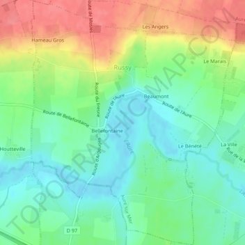
Name: Russy topographic map, elevation, terrain.
Average elevation: 35 m
Minimum elevation: 7 m
Maximum elevation: 80 m
Other topographic maps
Click on a map to view its topography, its elevation and its terrain.
Sainte-Honorine-des-Pertes
France > Normandie > Aure sur Mer > Sainte-Honorine-des-Pertes
Sainte-Honorine-des-Pertes, Aure sur Mer, Bayeux, Calvados, Normandie, France métropolitaine, 14520, France
Average elevation: 40 m
Russy
France > Normandie > Aure sur Mer > Russy
Russy, Aure sur Mer, Bayeux, Calvados, Normandie, France métropolitaine, 14710, France
Average elevation: 45 m