
Wiltz topographic map
Interactive map
Click on the map to display elevation.
About this map
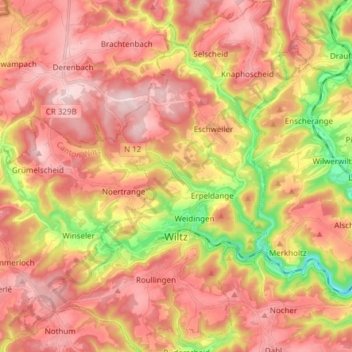
Name: Wiltz topographic map, elevation, terrain.
Location: Wiltz, Canton Wiltz, Luxembourg (49.93454 5.87787 50.03223 5.98019)
Average elevation: 423 m
Minimum elevation: 257 m
Maximum elevation: 530 m
La ville est traversée par la rivière Wiltz, un affluent de la Sûre. L'altitude varie entre 320 et 500 m.
Other topographic maps
Click on a map to view its topography, its elevation and its terrain.
Pintsch
Luxembourg > Canton Wiltz > Kiischpelt
Pintsch, Kiischpelt, Canton Wiltz, 9767, Luxembourg
Average elevation: 376 m
Pommerloch
Pommerloch, Winseler, Canton Wiltz, 9638, Luxembourg
Average elevation: 442 m
Eschdorf
Eschdorf, Esch-sur-Sûre, Canton Wiltz, 9151, Luxembourg
Average elevation: 456 m
Watrange
Luxembourg > Canton Wiltz > Lac de la Haute-Sûre
Watrange, Lac de la Haute-Sûre, Canton Wiltz, 9690, Luxembourg
Average elevation: 468 m
Flebour
Flebour, Boulaide, Canton Wiltz, 9633, Luxembourg
Average elevation: 426 m
Berlé
Berlé, Winseler, Canton Wiltz, 9636, Luxembourg
Average elevation: 442 m
Esch-sur-Sûre
Esch-sur-Sûre, Canton Wiltz, Luxembourg
Average elevation: 425 m