
Thank you for supporting this site ❤️
Make a donation
Make a donation
Dripping Springs topographic map
Click on the map to display elevation.
Thank you for supporting this site ❤️
Make a donation
Make a donation
About this map
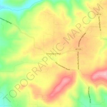
Name: Dripping Springs topographic map, elevation, terrain.
Location: Dripping Springs, Crawford County, Arkansas, United States (35.51314 -94.41827 35.55314 -94.37827)
Average elevation: 264 m
Minimum elevation: 172 m
Maximum elevation: 340 m
Thank you for supporting this site ❤️
Make a donation
Make a donation
Other topographic maps
Click on a map to view its topography, its elevation and its terrain.
Thank you for supporting this site ❤️
Make a donation
Make a donation
Thank you for supporting this site ❤️
Make a donation
Make a donation