
Make a donation
Mount Lofty topographic map
Click on the map to display elevation.
Make a donation
About this map
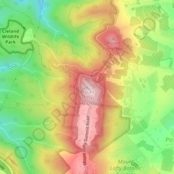
Name: Mount Lofty topographic map, elevation, terrain.
Average elevation: 554 m
Minimum elevation: 398 m
Maximum elevation: 709 m
Make a donation
Other topographic maps
Click on a map to view its topography, its elevation and its terrain.
Make a donation
Make a donation
Make a donation
Stirling
Many deciduous trees, particularly the maple, elm, oak and ash trees, have been imported from Europe and North America. These trees flourish in Stirling's wet and mild to cool climate and are a popular tourist attraction in the autumn months (April–May), bringing rich and vibrant autumn leaf colour to the…
Average elevation: 504 m
Make a donation
Make a donation
Mount Barker
Mount Barker is located on the plains surrounding the Mount Barker Summit, about 2 km west of the mountain itself, at 35°04′S 138°51′E / 35.067°S 138.850°E / -35.067; 138.850. Mount Barker is south east of Mount Lofty and Adelaide. It is to the north of The Coorong, and the west of Murray…
Average elevation: 368 m
Make a donation
Lake Bonney Riverland
Australia > South Australia > The Berri Barmera Council > Barmera
Average elevation: 16 m
Make a donation
Make a donation
Gumeracha
Gumeracha is also home to Applewood Distillery, Australia's highest altitude distillery, specialising in Gin and Amaro showcasing native Australian botanicals like finger limes and strawberry gum.
Average elevation: 408 m
Williamstown
Williamstown has an elevation of 310 m and an average rainfall of 680 mm. It has a summer average temperature of 31 °C with temperatures often reaching the mid 40s, and a winter average temperature of 15 °C, with nights dropping below freezing, which makes the region excellent for the cultivation of fruits,…
Average elevation: 310 m
Make a donation
Make a donation
Lyndoch
Lyndoch is a town in Barossa Valley, located on the Barossa Valley Highway between Gawler and Tanunda, 58 km northeast of Adelaide. The town has an elevation of 175m and an average rainfall of 560.5mm. It is one of the oldest towns in South Australia.
Average elevation: 216 m
Make a donation
Make a donation
Make a donation
Make a donation
River Torrens
Australia > South Australia > Adelaide City Council
Public baths were built in 1861 just north of the current Parliament House. They were supplied with reticulated water from the Torrens and progressively upgraded with the last change a 1940 remodelling including an Olympic-size swimming pool and diving tower. The baths were demolished in 1970 to make way for…
Average elevation: 269 m
Make a donation
Make a donation
Make a donation
Make a donation
Make a donation
Make a donation
Make a donation
Make a donation
Make a donation
Make a donation
Make a donation