
La Yesa topographic map
Interactive map
Click on the map to display elevation.
About this map
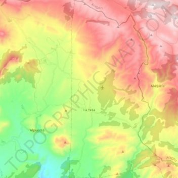
Name: La Yesa topographic map, elevation, terrain.
Location: La Yesa, La Serranía, Valencia, Comunidad Valenciana, España (39.83916 -0.98153 39.97574 -0.89506)
Average elevation: 1,155 m
Minimum elevation: 715 m
Maximum elevation: 1,622 m
Other topographic maps
Click on a map to view its topography, its elevation and its terrain.
Picarcho
España > Comunidad Valenciana > La Serranía > Tuéjar
Picarcho, Tuéjar, La Serranía, Valencia, Comunidad Valenciana, España
Average elevation: 1,098 m