
Chanxhe topographic map
Interactive map
Click on the map to display elevation.
About this map
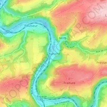
Name: Chanxhe topographic map, elevation, terrain.
Location: Chanxhe, Sprimont, Liège, Wallonie, 1771, Belgique (50.47935 5.57556 50.51935 5.61556)
Average elevation: 183 m
Minimum elevation: 87 m
Maximum elevation: 287 m
Other topographic maps
Click on a map to view its topography, its elevation and its terrain.
Gomzé-Andoumont
Belgique > Liège > Liège > Sprimont
Gomzé-Andoumont, Sprimont, Liège, Wallonie, 4140, Belgique
Average elevation: 238 m
Dolembreux
Belgique > Liège > Liège > Sprimont
Dolembreux, Sprimont, Liège, Wallonie, 4140, Belgique
Average elevation: 233 m